Clatskanie People’s Utility District (CPUD) serves approximately 4,600 customers in heavily wooded northern Oregon adjacent to the Columbia River. The utility is committed to public safety, customer service, and conservation.
Challenge
Wildfire has become an increasing concern in the Pacific Northwest in recent years. As a result, wildfire mitigation plans are required of utilities in Oregon, and risk analysis is an integral part of those plans. Risk analysis is essential because blanket mitigation can be problematic across an entire utility district. However, if high-risk areas are identified, they can be sectionalized, and mitigation strategies can be applied more surgically.
Smaller utilities with limited staff and resources are challenged to create meaningful plans. The primary risk profiles available from state and federal agencies suffer from very coarse resolutions, and they lack local knowledge and utility-specific data. Additionally, consultants for a custom analysis can be expensive. Manual methods used by other small utilities are often subjective and lack enough detail to be very scientific. CPUD needed a way to conduct a meaningful risk analysis for its wildfire mitigation plan with available data and in-house resources.
Solution
CPUD uses ArcGIS as its system of record to manage electric infrastructure. The utility leveraged public and in-house GIS data and spatial analysis to evaluate the entire service area with repeatable results.
Wildfire risk is generally deemed an accumulation of dangers. These include the likelihood of a fire starting, the potential for fire propagation, and the potential catastrophic effects on people and property. Therefore, CPUD needed to consider many factors for a thorough risk analysis.
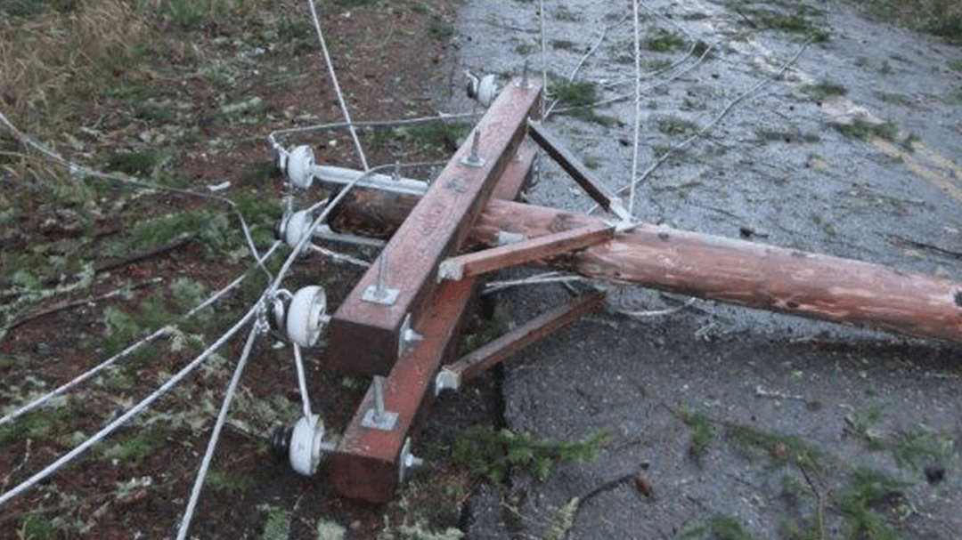
Energized equipment can create sparks that have the potential to start fires when contacting dry vegetation or other fuels. Sparks may occur when a fuse operates or equipment fails, but the most common cause is downed power lines, often from tree contact.
 Trees are the most common cause of downed power lines.
One of the most significant influences in fire propagation is topography. Fire is more likely to occur on dry, south-facing slopes, and it spreads faster on steeper slopes. Due to difficult access, it is also harder to combat fire on steep terrain. Another critical factor is the distance from firefighting resources. Longer travel time allows a fire to intensify before firefighters arrive, increasing the damage potential.
Uncontrolled wildfire becomes catastrophic when people and properties lie in its path. This concern increases as new homes appear in and around forested areas, in the area known as the wildland urban interface (WUI). Additionally, road distance and the number of exit routes affect people’s ability to evacuate safely from the path of a wildfire.
CPUD utilized detailed asset information, outage history, population density, vegetation height and type, road condition, and lidar elevation data to model these known risk factors. As a result, a rich set of data supported an impressive evaluation of wildfire risk.
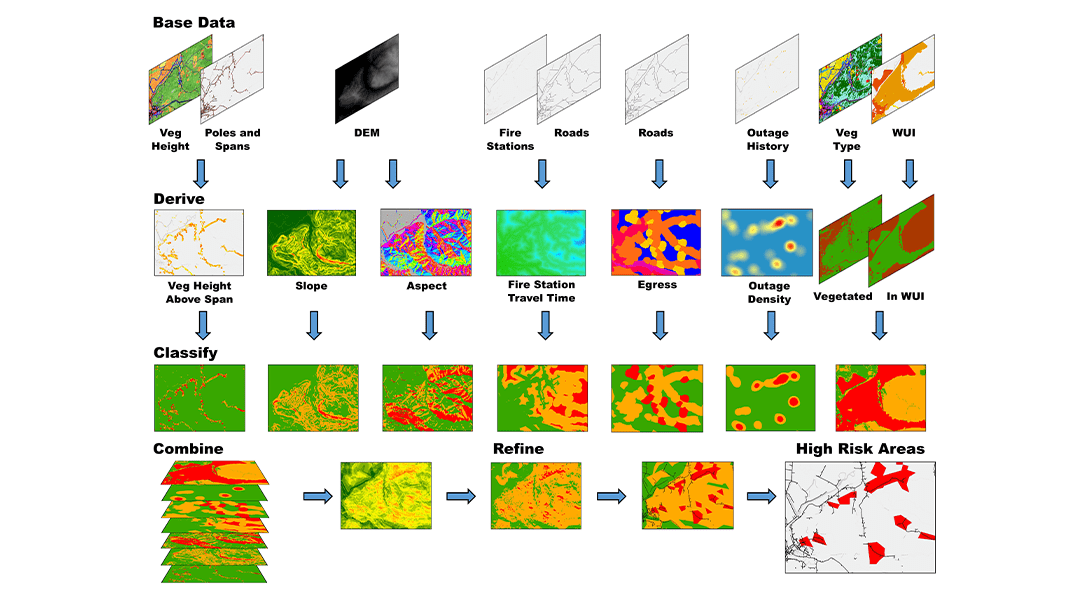
 The comprehensive risk analysis model uses ArcGIS Spatial Analyst.
Staff employed this knowledge to create a set of submodels and raster surface inputs using ModelBuilder and ArcGIS Spatial Analyst. Next, information is carefully classified, representing low, medium, or high risk. Finally, all inputs are overlaid using the Raster Calculator tool to create a composite of all risk factors across the district. The final result classified overall wildfire risk across the district into low-, medium-, or high-risk categories.
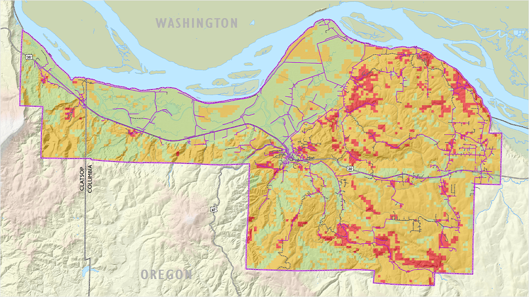
 Diverse data and analysis resulted in a detailed fire risk assessment of the service territory.
Results
The spatial analysis identified discreet fire risk areas for the entire CPUD electric system. Using maps of these areas, the operations manager can sectionalize the distribution system to mitigate the potential impacts of fire. For example, CPUD retrofits with non-expulsion fuses, adds covered conductors, and modifies recloser settings based on the risk profile. In addition, CPUD may apply public safety power shutoffs to the highest-risk areas in worst-case scenarios.
Maps of both the inputs (risk setting) and the final result (risk analysis) support the wildfire mitigation plan provided to the CPUD board and the Oregon Public Utility Commission (PUC). In addition, some of the inputs help CPUD focus vegetation management efforts on previous trouble spots, reducing unplanned outages and mitigating fire risk. Ultimately, the analysis allows CPUD to provide the safest and most reliable power while helping to safeguard the community from utility-caused fires and keeping electricity prices as low as possible for its customers.


